The Geology of the British Isles / UK
Understanding as per 1950
Page Naviagtion
Introduction
The present
surface features of the British Isles, as well as their relationship to the
features of the neighbouring parts of the Continent of Europe, are the
reflection of the long and complicated geological history of the area. Geology
has been described as geographical evolution, but, conversely, the existing
physical geography of a country is the result of its geological evolution from
the dawn of
geological time to the present day.
The
geologist has divided geological time into at
least five great eras and each of those eras into a number of periods. On broad
lines the rocks which were laid down in each of those periods can be made to
tell the story of the earth’s history. Each period was characterised by its own
sets of animals and plants, the remains of which have been entombed in the rocks
and can be found to-day as fossils. Nor are these episodes in the past history
of the earth merely of academic interest. Whether it be in the search for
minerals of economic importance or the study of the disposition of those dep
osits when found in its relation to economic costs of
mining; whether it be the study of the rocks of the earth’s crust in
relations hip to the soils which they afford or in relationship to construction
on the earth’s surface, the studies of the geologist are of fundamental
importance. No excuse, therefore, need be made for considering in this chapter
the physiographic evolution of the British Isles, by attempting to trace the
history of these islands from the earliest times to the present.
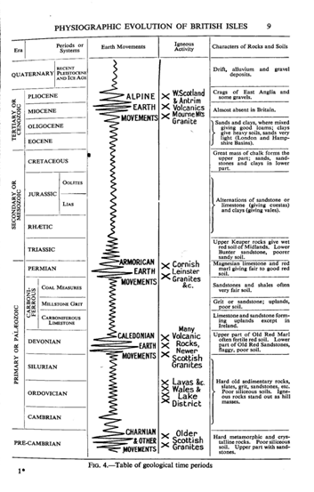
The Five Eras
The five eras—the Pre-Cambrian (in the rocks of which earliest era no remains of
life are commonly found), Primary or Palozoic, Secondary or Meozoic, Tertiary or
Kainozoic (Cenozoic), and, finally, the Quaternary or Modern Period—are the
great divisions which the geologist has made in the geological time scale. Subd
ivisions of these are shown in the diagram, Fig. 4. Further subdivisions are of
course made, but those listed are of fundam ental importance in that they are in
common use for numerous purposes.
Little is known of the geography of Pre-Cambrian times. The rocks of this great
era found in the British Isles fall into three main groups:
Not unnaturally the few fossils which are found
in the Old Red Sandstone are of fish,
the first back-boned creatures (which lived in the transient lakes of
the great mountain valleys) and primit ive land plants. The enormous
thickness of many of the Old Red Sandstone deposits testifies to the
rapidity with which the Caled onian mountains were worn down by the
agents of atmospheric weathering. Towards the close of the Devonian
period the mount ains were already but mere remnants of their former
selves and they yielded only fine sand and red mud or marl. The
beginning of the succeeding period—the Carboniferous—was marked by a
great invasion by the sea of practically the whole area. The sea flowed
into the pre-existing mountain basins, except in the north where there
still existed the great continental mass, whose remnants now form the
Highlands of Scotland. Over England and Wales and much of Ireland the
mountains had been worn down to such an extent that they yielded but
little sediment. In the waters of the Carb oniferous sea there
flourished a wealth of corals and other organi sms which are favoured by
clear water; and so the deposits laid down were limestones
(Carboniferous Limestone). The name once used for Carboniferous
Limestone was the Mountain Limestone indicating the association of this
limestone with mountain or upland areas, particularly of the Pennines.
But the great continent which extended from Scotland to Scandinavia
yielded sediments which prevented the extensive growth of clear-water
organisms in what is now the north of England and the Midland Valley of
Scotland. So here one does not see the great thicknesses of
Carboniferous Limes tone found farther south; instead there are thin
beds of limestone in a mass of sandstones and shales. These sandstones
and shales represent material brought down by rivers draining from the
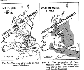
northern continent. In the middle of the Carboniferous period a huge
river gradually began to overwhelm the British area and to spread its
great deposits of sand on top of the limestone which had been just
formed. We have really in Britain the formation of an enormous delta,
and because of the former use of the sandstone of these deltaic
deposits as millstones the deposits are known as the Millstone Grit. The
Millstone Grit delta extended from Scotland right across the Midlands of
England
as far as an island, or perhaps a peninsula from a European mass, known
as St. George’s Land, which ext ended from Central Wales through the
heart of England.
The great delta which was formed during
Millstone Grit times prepared the way for the very widespread growth of
swamp forests in the succeeding period of the Coal Measures. The forests
of tree ferns and allied plants, whose remains form the coal seams of
the present day, flourished in swampy tracts which have been comp ared
by some to the mangrove swamps of the tropics of to-day,
nd by others to fresh-water swamp forests such as the
extensive Dismal Swamps of the United States in Virginia. Conditions suita ble
for the growth of such forests were to be found along the margins of the
Scottish land mass as early as Carboniferous Limes tone or Millstone Grit times,
but it was not until the deposition of the great Millstone Grit delta that
conditions became suitable over the huge area between the Scottish land mass,
where now one finds the Scottish Highlands, and that land that existed across
the middle of Britain and to which the name of St. George’s Land has been given.
There is little doubt that the Coal Measure forests grew over continuous areas
from what is now the Scottish border to the Midlands of England, and right
across the area where now the Pennine Upland is found. To the south of St.
George’s Land, in what is now South Wales, the Forest of Dean, the Bristol area,
and right across southern England through east Kent into northern France and
Belgium there were similar conditions equally suitable for the growth of
forests. It is clear that at intervals the forests were overwhelmed, and indeed
entombed, by masses of sand and mud which were brought down by rivers similar in
character to those which deposited the Millstone Grit. At other times the slight
changes in surface level caused an inrush of the sea, and so in parts of the
British Coal Measures there are found thin marine bands. Under most of the
British coal seams there are found beds of clay, often with traces of roots, and
it would seem that these Coal Measure swamp forests grew in a dark muddy slime,
not very different from that in which mangrove swamps grow at the present day.
Somet imes this layer of clay underneath the coal seams is of value in that it
furnishes fireclay. Occasionally it has become silicified and is important as
“ganister.” There is little doubt that the land masses of Coal Measure times had
been worn down greatly, in fact almost to sea-level, and towards the close of
the period there is evidence that desert conditions prevailed on the
neighbouring land masses.
The close of Coal Measure times is marked in many
parts of the world by a great series of mountain-building movements, frequently
known as the Carbo-Permian earth movements, since the succeeding period is that
of the Permian. In the British Isles these movements resulted in four sets of
folds:
(1)In the north and north-west
of the islands the CarboP ermian movements resulted in the accentuation of
pre-existing folds which had been formed by the Caledonian earth movem ents.
(2) In such areas as central Wales new folds were formed,
broadly speaking parallel to the pre-existing Caledonian folds, that is with a
trend from south-west to’ north-east. The great anticline of the Vale of Towy in
Central Wales is a good example. (3) The most characteristic
folds, however, of the Carbon Permian earth movements are those which have an
east and west trend and which are best exemplified in the folding of South Wales
and the formation of the South Wales coal basin. The highly complex folds with
their axes roughly from east to west which are found in Devon and Cornwall are
also of this period, and there they were accompanied by the intrusion of vast
masses of granite. On the other side of the Channel the east-west folds of
Brittany are of the same age. Brittany, or “Armorica,” shows the folds of the
Carbo-Permian earth movements so well that they are known as the Armorican
earth movements or, alternately, as the Hercynian, from the Harz mountains of
Germany. i
(4) In other parts of England north-south folds characterise
this period and there is little doubt that the general uplift of the Pennines
which resulted in the separation of the Coal Measures into an eastern and a
western series of basins originated at this time. Another north-south fold
typically Carbo-Permian is the line of the Malvern Hills, which now forms the
eastern limit of the massif of ancient rocks making up Wales.
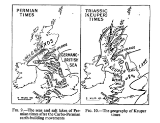
As a result of these great Armorican earth
movements, at the beginning of Permian times
Britain was
occupied by an important series of mountains, between which there were deep
mountain-girt desert basins—and naturally the earliest Perniian deposits are
usually coarse breccias which are of the nature of screes from the newly formed
mountains. Beds of coarse conglomerate and boulders, laid down by torrential
streams, are also found. There is one very well-known Permian basin containing
rocks of this character, and that is the one which occurs in the south-west,
over the eastern parts of what is now the county of Devon and the neighb ouring
parts of Somerset. A great sea, or possibly salt-water lake, comparable to the
Caspian at the present day, covered much of Germany. It may, or may not, have
been continuous with the main ocean which lay to the south of Europe. This
German sea stretched across the North Sea and its western shores were to be
found in northern England. After the early sandy deposits the well-known•
Magnesian Limestone was laid down in the north of England and is found in its
best development in Durham and Yorkshire. The waters of the Magnesian Sea seem
to have found their way round the southern edge and perhaps across the north of
the newly formed Pennines, and attenuated remnants of the Magnesian Limestone
are therefore found on the western side of the Pennines. There is little doubt
that the land surrounding these areas was under desert-like conditions; most of
the sandstones and marls of Permian age are red; many of thçm contain grains of
sand worn smooth by wind action. The Permian deposits thus form the lower part
of what the older geologists described as the New Red Sandstone. This name was
not ill-chosen, since the conditions of deposition of the beds must have closely
resembled those of the Old Red Sandstone.
Although the Permian
is the youngest of the Primary or Palozoic systems, there is little break in
England between the Permian dep osits and those of the succeeding Trias, the
oldest of the Secondary or Mesozoic. The Trias takes its name from the
three-fold division which is possible in the rocks of this series in most parts
of northern Europe into Bunter, Muschelkalk, and Keuper. The coarse red
sandstones and pebble beds of the Bunter period were laid down in basins dried
up. Many of the deposits are ripple-marked; others show “pittings” due to rain
storms on the scarcely dry mud. This was an age when giant reptiles
first began to be important and the remains of some of them are entombed
in the Triassic deposits.
Some of the masses of older rocks—the remnants of the CarboP ermian
Mountains—stood up as islands in the Triassic salt lake or sea of the Midlands
of England. Examples are preserved to us to-day in the Wrekin, the Lickey Hills,
and the hills of Charnwood Forest, so that one finds the red Keuper deposits
wrapping round the margins of the ancient rocks. It is the red Keuper Sandstones
and Marls together with glacial drifts largely derived therefrom which are in
the main responsible for the red soils so common in the Midlands of England. The
Mans give rise to a soil which is rich, though tendiig to be waterlogged, but
fertile for agricultural purposes if well drained.
The next phase in the physiographic evolution
of the British Isles began with the irruption of a sea into the old Triassic
basins. Many of the creatures living in the Triassic Sea, such as fishes, were
killed off by this sudden incursion of marine waters, whilst organisms which
were brought in by the marine waters found thems elves unable to survive under
the new conditions. Hence it is not surprising to find the earliest deposits of
the Rhtic, as the succ eeding period is called, consist frequently of “bone
beds,” built up entirely of the remains of fishes and of reptiles. But in
time the sea covered the whole area of the Triassic basins and even overs tepped
them on to the neighbouring land masses. By this time the land masses were worn
down so that the material they yielded was more often of the nature of fine
sands and muds, rather than coarse deposits. Conditions favoured the development
of certain types of limestone. Deposits attributed to the Rhtic on the Continent
of Europe often attain a great thickness but in Britain the whole period is
represented by only a thin series of deposits. The important Jurassic period
which succeeds it is represented by a great series of beds which can be divided
into three great groups. The Lower Jurassic deposits were the Liassic deposits
and are mainly of clay or mud, argillaceous limestones, and occasional sands. In
the water of the Jurassic seas enormous numbers of the well- known ammonites
flourished, and these are really the dominant fossils of the period.
Although there were no great earth-building
movements during the Jurassic period, there were doubtless small folding
movements; and the deposits of the Middle
Jurassic comprise limestones, sandstones, and clays laid down in the
tranquil waters of basins more or less cut off from one another.1 Where
the waters were clear and free from sediment the conditions were
particularly roughly the same areas as the Permian deposits. Like the
Magnesian Limestone, the Muschelkalk of Germany and much of Europe was
laid down in an inland sea, doubtless a salt-water sea, which, like the
Magnesian Limestone sea, stretched from Germany across towards England.
The Muschelkalk itself as a limestone is, howe ver, absent from England.
Here the Bunter Sandstones are succeeded by a considerable thickness of
red sandstones and mans (Keuper) which were clearly laid down in a
shallow basin surr ounded by desert country. At intervals this basin was
dry, for one finds deposits of salt (of considerable economic
importance) and gypsum representing salts that were deposited when the
shallow
suitable for the accumulation of the well-known
Oolitic Limestones, and the famous freestones
of Bath belong to this period. In the Upper Jurassic, on the other hand, clays
and sands again predominate over the calcareous deposits though the famous
Portland stone is of this age. The difference between the soft and easily eroded
clays and the harder beds by which they are separated has been a factor of the
utmost importance in determining the relief of the present day south-east of
England. Towards the close of the Jurassic period the sea retreated to the
north-east, whilst the extreme south-east of England was covered by a great
lake, the Wealden Lake, which stretched across what is now the English Channel
into France. In this Wealden Lake were laid down deposits of sand and clay, such
as the Hastings Sand and the succeeding Weald Clay found at the present day in
the heart of the Weald of Kent, Surrey, and Sussex. Around this Wealden Lake
lived enormous numbers of giant reptiles such as Iguanodons, whose remains are
found in the lake deposits. In the seas which still covered the north-east of
England were dep osited various beds, including the Speeton Clay of Yorkshire.
Just as the Triassic Lake basins were later invaded by Rhtic seas, so the
Wealden Lake basin and the northern marine area were afterwards invaded by the
sea of the earlier Cretaceous period. Naturally the earlier deposits were sands
and muds, but there had been no extensive earth-building movements affecting
Britain since Carbo-Permian times, so that the land surrounding the invading
Cretaceous seas were low and yielded but little sediment. There is evidence that
on these lands a desert type of climate prevailed. After the formation of the
Greensand and Gault Clay deposits the waters of the Cretaceous seas became
deeper and were extremely clear. The conditions thus favoured the deposition of
one of the most famous of all the deposits found in the British Isles, that rem
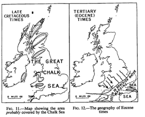
arkably pure white limestone which we know as Chalk. It used to be thought that
the Chalk was laid down in deep water under conditions comparable to those
prevailing in the open Atlantic Ocean where white “oozes” are being formed at
the present day, but it is now believed that the Chalk sea was not necessarily a
deep sea, but merely one in which the water was clear owing to the absence of
sediment brought from the land. The Chalk itself consists partly of the remains
of multitudes of tiny organisms, particularly of foraminifera. The exact limits
of the Chalk sea in Britain are not easy to determine. It is believed by many
that the peneplanation or the smoothing of the mountains of Wales, and possibly
even of parts of the Highlands of Scotland, is due to the action of the waves of
the Chalk sea.
The Cretaceous is the youngest of the periods of the great Mesozoic or Secondary
era. Although in Britain there is comparatively little discordance between the
bedding-planes of the Chalk and of the succeeding deposits there is a great
change of character between the two. There was actually a considerable lapse of
geological time between the deposition from highest Chalk and the succeeding
beds.
The earliest of the
Tertiary deposits in Britain are the
Eocene, and with this period Britain began to assume some of the relief
features which are so familiar at the present day. Most of Britain seems
to have risen so as to form a great land mass and only the south-east of
the country was covered by a sea. Into this sea there emptied one or
more great rivers coming from the west from a continental mass which is
now beneath the waves of the Atlantic Ocean. The rivers laid down sands
and other deposits of pred ominantly continental origin in the western
parts of what we call the Hampshire and London Basins, whilst towards
the east of these same basins there were being deposited clays or muds
containing marine fossils. There is on the whole an alternating
succession of deposits of marine and continental origin which marks the
various backward and forward movements of the marine waters of the Eoc
ene sea.1 The same sea covered the well-known Paris Basin in the
northern part of France as well as considerable tracts in Belgium and
Holland. It was during the Eocene period that there occurred some
Economically this is of the utmost importance because of the variety of
soils and consequent land utilisation which result.
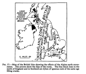
of the earlier earth tremors which were gradually
to increase in strength and to culminate in those earth-building movements which
were the most important of all in determining the present physical geographyof
Europe—the Alpine earth movements. It seems likely that the Wealden dome in
south-eastern England began to rise during the Eocene period.
The Oligocene period, which succeeds the Eocene, has left but little trace in
Britain. If there were Oligocene deposits laid down in the London Basin they
have been removed by denudation and Oligocene deposits are almost restricted in
this country to the Hampshire Basin. Towards the close of the Oligocene and
during the succeedi ng Miocene period the great Alpine storm broke. This great
period of earth-building movements formed the Alps, the Carp athians, and many
of the other great mountain chains of the world. The British Isles were
comparatively little affected, since earlier folding movements had exerted their
full influence in the north and the north-west of the country and resulted in
the formation there of great stable blocks too rigid to be further folded by the
earth-building movements so paramount in central Europe, and were at the same
time too distant from the main seat of the Alpine storms. It is to be expected
that the southern parts of England would be the areas most affected by the
Alpine movements; that is actually the case. The folds, for example, which run
across the Isle of Purbeck and the Isle of Wight are of this age. The main
folding of the Weald is also of the same date. Whilst the ancient rocks of the
north of the British Isles were not folded they were
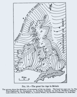
The arrows show the direction of movement of the ice sheets. The local ice caps
are: Ia, North West Highlands; lb. Grampians; lc,
Southern Uplands; a and 2b, Northern Ireland;
3a. Lake District; 3b,
North Wales; 3c,
Central Wales; 3d,
Southern Pennines; 3e,
Irish Sea.
rent and torn, and through some of the fractures burst enormous flows of molten
rock giving rise to the lava plateaus of Antrim in Northern Ireland and of many
parts of western Scotland, whilst some of the great granitic intrusions, such as
the granite mass of the Mourne Mountains in Ireland and some in Scotland, belong
to the same period. The succeeding Pliocene period saw Britain taking on very
much tbc f9rrn that it has at the present day.
sea lingered in what is now the London Basin and later
retreated farther north and occupied the position of what is now the North Sea,
so that Pliocene deposits in this country are restricted, broadly speaking, to
the
London Basin and to East Anglia. More important than the deposits left
behind was the work of Pliocene seas, in cutting those flattened surfaces,
bevelling many of our hills especially in southern England. It is only in recent
years that the geological history of the times has been worked out from this
fragmentary evidence.
There was still to come, however, an episode in the geological history of these
islands which has left its mark in nearly all places;
FIG. 15.—Glen Etive, Western Scotland—a typical U-shaped
glaciated valley in the Highlands, showing a complete absence of spurs and that
was the great Ice Age. At the height of the Glacial Period the greater part of
the British Isles was covered with ice sheets. Some of these were of local
origin and had their centres in such upland areas as the Highlands of Scotland,
the Southern Uplands or the mountains of Ireland, whilst other parts of the
British Isles, particularly the east, were affected by the enormous ice sheet
which crossed the North Sea from the main centre of the Scandinavian mountains.
The southern limit of the ice sheets in Britain ran roughly along the present
day line of the Thames, so that Britain south of the Thames and of the Bristol
Channel was not actually covered by the ice sheet. The Ice Age is of enormous
importance because of the way in which the ice-sheets and glaciers moulded the
surface of the country and left behind them various superficial deposits which
are frequently of much greater importance in determining the character of
surface utilisation than are the und erlying solid deposits to which the
geologist pays greatest attention. Thus the ordinary geological map of the
British Isles is really of comp aratively little use to the geographer in his
attempt to interpret the effect of soil on human activities and as a factor in
the human env ironment. It is of utmost importance that he should consider what
the geologist calls the “drift” map, the map which shows not only the solid
rocks underneath but the superficial deposits, many of which are directly or
indirectly connected with the great Ice Age. In general it may be said that the
great Ice Age had at least the following effects
(1) The ice removed much of the soil which must
previously have been formed in the mountainous areas and has rendered huge
tracts of the Highlands of Scotland, for example, almost devoid of soil and
therefore comparatively useless for agricultural purposes. The older rocks are
exposed at the surface and have been smoothed by ice action, and one sees in the
rounded outlines of the relief of the Highlands some of the results of the work
of ice. Tongues of ice scooped out pre-existing valleys and smoothed the sides
and gave the characteristic U-shaped valleys, with sides almost devoid of soils,
which one finds throughout the Highlands and, indeed, in many parts of northern
England and Wales and of Ireland.
(2) Over the low-lying areas glacial deposits were laid down. Some of these
consist of coarse sands and even of boulders of morainic character. Elsewhere
there are boulder clays—stiff clays full of boulders of various rocks. Or again,
there are out- wash fans of gravel and sand which were laid down by torrential
waters caused by the melting of the glaciers. In the fourth place, some of the
finer glacial deposits were redistributed by wind, and whilst the climate of
England seems to have been too humid for the formation of vast quantities of
bess, which are found in regions where conditions south of the ice masses were
drier, the brick-earth of England has many of the characters of bess, and is
really bess deposited under more humid conditions or under water. These
brick-earths are essentially characteristic of the south of the country.
(3) Then the glaciers profoundly altered the drainage of the British Isles and
there are innumerable examples of pre-existing drainage which has been affected
by the Ice Age. Many ice- dammed lakes were left during and after the retreat of
the ice and to-day the fine sediments deposited in these glacial lakes afford
some of our most fertile lands.
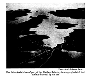
Since the retreat of the ice sheets from the British
Isles there have been several fluctuations in level. Evidences of these fluctuat
ions in level are found in the raised beaches which occur in many places along
the coasts, whilst movements of the opposite character are evidenced by
submerged forests. Then, again, one must always remember that there has been a
progressive change from the extreme cold of the great Ice Age to the climatic
conditions surface drowned by the sea which are found at the present day, though
the change may have been interrupted by cyclic fluctuations. The spread of the
present vegetation into these islands must have been governed by the changing
climatic conditions; doubtless, very considerable portions of the pre-glacial
flora managed to persist in the south of the country and formed the nucleus for
the reclothing of the British Isles.
The evolution of the
rivers and drainage system of
Britain will be separately considered; but it should be borne in mind
here that there was a drainage system in existence prior to the
formation of the ice sheets of the great Ice Age, and that this earlier
drainage system was profoundly affected by ice action, and that the
present river system of these islands reflects in most cases the result
of glacial interference.
References.—The reader will find the
evolution of the present geography of the British Isles treated along
these lines in L. D. Stamp’s Introduction to
Stratigraphy (Thomas Murby & Co.,
London, Third Edition, 1950) and in L. D. Stamp’s Britain’s
Structure and Scenery (Collins, London,
1947). The same subject is elabora ted in greater detail in L. 3. Wills’ Physiographic
Evolution of Britain (Edward Arnold,
1929). In these works full references will be found. In addition
Professor Wills has prepared a Paheogeographical
Atlas (Blackie, London, 1951).