By considering the changes in the distribution of land
and water over successive geological periods, we have traced in bare outline the
evolution of the physical geography of these islands. In the present chapter we must
analyse the physical geography as it is at the present day. Leaving on one side for
the moment the island of Ireland, the island of Britain is broadly divisible
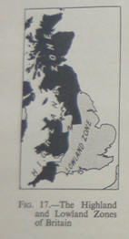
into two parts: a Highland Zone on the north and west, a Lowland Zone on the
south and east. It is possible to suggest more than one line which may be used
to separate these two divisions, but the most satisfactory seems to be that used
in Fig. 17 and elsewhere in this book (see Chapter XXIV) and which cuts across
the country, following a somewhat irregular course, from the mouth of the River
Exe in the south-west to near the mouth of the River Tees in the north-east. It
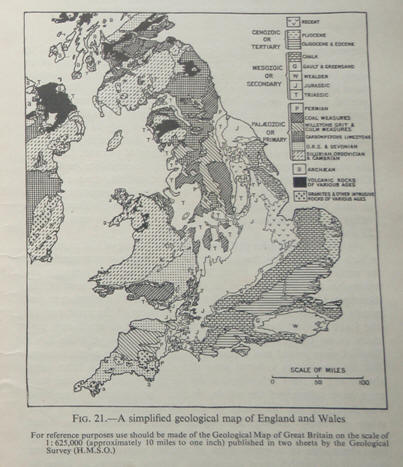
is roughly the line separating the outcrop of the old Paheozoic rocks on the one
hand and the younger Mesozoic and Tertiary rocks on the other. To the north and
west of the line lie the remnants of the great mountain chains which were built
up by successive earth building movements of Pre-Cambrian, Siluro-Devonian, and
Carbo-Permian times. The mountains are but remn ants of their former mighty
selves, but they still comprise the major mountain and hill masses of Britain.
Generally the most ancient masses are those which occur, as in the case of the
Highlands of Scotland, farthest to the north-west. Naturally the margins of the
ancient rocks are not infrequently covered by strata of later ages. To the south
and east of the line one finds first the broad plains or low-lying plateaus,
built up mainly of Triassic rocks, which constitute the Midlands of England. Not
infrequently small remnants of the ancient mountains stand up as islands in the
midst of these plains of younger rocks. Farther southwards and eastwards the
MIdland plains give place to what may be called, in the broadest possible sense,
the scarplands of England. Indeed, it is possible to draw another line across
England, again somewhat irregularly, from the Dorset coast to the north
Yorkshire Coast. To the south and east of this line lie low ridges, separated by
shallow valleys, which mark respectively the Outcrop of the harder or more
resistant and softer or less resistant beds respectively of the geological
sequence from the early Jurassic onwards. Like the Trjassjc rocks of the
Midlands, these rocks rest upon an ancient platform which lies buried beneath
them at a greater or less depth. Sometimes, as for example under London, the
ancient platform is within a thousand feet of the surface. At other times the
Paheozoic platform lies at such a depth that the full thickness of the overlying
beds has never been penetrated by the boring tools of the well-engineer. The
Jurassic and later rocks have themselves been gently tilted, usually towards the
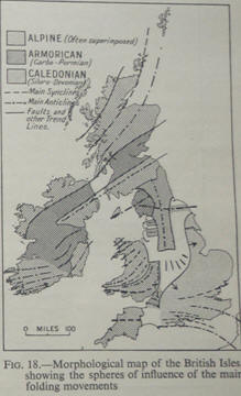
south-east, by the Alpine system of earth movements; but it is only in the
extreme south that there are signs of what might be called severe folding. For
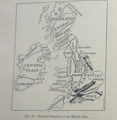
the purposes of a preliminary account we may distinguish in Britain the broad
physiographic and structural units described in the following pages.
THE HIGHLAND
ZONE
(1) The Highlands of Scotland.—The Highlands of Scotland are built up for the
most part of great masses of ancient metamorphic or crystalline rocks—gneiss, schists, slates, and quartzites. Some of the folding doubtless took place in
Pre-Cambrian times, and it would seem that some of the great intrusions of
granite and of other rockS are
of
(lie same date. The great period of earth movem
ents which determined the major structures of the Scottish Highl ands was.
however, the Caledoflian, or Siluro-Dcvonian. These movCfllcnts gave rise to
great mountain chains with a general grcnd from south-wCSt to north-east, and
this is still the dominant grain of the countrY. Bctwccn the great mountain
chains were ihc deep basins in which the deposits of the Old Red Sandstone were
laid down.
Much of the Highlands of Scotland has probably
remained land from those very remote ages to the present day, and consequently
sub-aerial denudation has gone on almost continuously, culminating with the work
of the great ice caps which covered Scotland during the last glacial epoch. As a
result, the Highlands of Scotland of to-day no longer present the highly
accidented scenery of the younger mountain belts of the world, but rather the
rounded outlinea
which betoken the results of eons of sub-aerial
denudation and the work of ice. On the whole, then, the Highlands form an
irregularly suifaced P!ateau with its greatest elevation along the western
margin, sloping On the whole towards the east. The plateau surface has in general an average elevation of
between 2,000 and 3,000 feet; some of the higher points often marking the
outcrops of granite, of both Pre-Cambrian and Sjluro-Devonjan ages. The highest
points may reach over 4,000 feet, and included amongst them is Ben Nevjs, the
highest mountain in the British Isles, of 4,400 feet. The Scottish Highlands are
divided into the North-West Highlands and the Central Highlands or Grampians by
the great cleft of Glen More. The North-West Highlands are by far the more
rugged and the grander, and meet the Atlantic Ocean in the intricate forded and
island-bounded coast of western Scotland. It seems possible that the Alpine
earth movements, being unable to fold the old stable block, tended to fracture
it ins tead, and the belts of crushed rock which were formed along the fractures
have been more easily excavated by rivers and by ice, and by the waves of the
ocean, thus giving rise to the fords with their remarkable rectangular bends.1
Through some of the major cracks, The system of major cracks developed along the
western coasts of Scotland may be due to pressure exerted from below by masses
of molten rock attempting to find an outlet. Just as when one presses with the
point of a stick on a sheet of ice covering a pond, or when a stone is thrown
through a window, both conc entric and radial cracks would be developed, and it
would seem that this explains the varied directions followed by the fords and
valleys of the area. See J. W. Gregory, “The Origin and Nature of Fiords”; and
J. W. Gregory, “The Scottish Lochs and their Origin,”
Proc. R. Phil. Soc. Glasgow, XLV. 1914, 18,3—196.
Rocks of Tertiary age have welled up and give rise
to the marked lava plateaus of Skye and SOniC other parts of the western coast of Scotland,
comparable in character to those found in Icel and. The Old Red Sandstone,
originally deposited in valleys, still tcnds to occur in valley or lowland
situations, but the more resistant rocks of the period may cover considerable
stretches, as they do over CaithflC5 The ancient rocks of the Highlands on the
whole give rise to a poor tyPe of soil, whilst much of the soil which must
previously have been formed has been swept away from most of the higher areas by
the ice sheets of the glacial epoch. The tracts occurring on the Old Red
Sandstone are, on the whole, more fertile. The same is true of the lower eastern
margins of the ancient rocks themselves, as for example in the area known as the
Buchan Plateau. GeograPhicY the eastern margins, whether they are on the ancient
rocks or on Old Red Sandstone, are somewhat distinct from the main mass of the
Highlands and are frequently considered as a separate region under the title of
North-Eastern Scotland. It should be noted that the Orkney Islands form a
detached portion of this area, whilst the Shetland Islands, farther north,
resemble more closely the central part of the Highlands themselves. The southern
limit of the Highlands of Scotland is remarkably well defined by the great
Highland boundary fault, actually a succession of faults, which runs across the
country with a Caledonian trend, from the mouth of the Clyde to the east coast
in the neighbourhood of Stonehaven. The faults seem to have been initiated at
the same time as the Caledonian earth movements, but intermittent movem ents
along them have undoubtedly occurred from that time until the present.
(2) The Southern Uplands.—The Southern Uplands
consist of the denuded remains of a great mountain chain of Siluro-Devonian
age and which runs across the south of Scotland from the southw est to
the north-east, that is with a characteristically Caledonian trend.
There is, however, a marked difference between the Southern Uplands and
the Highlands, in that the rocks of which the Southern Uplands consist
are sediments, mainly of Ordovician and Silurian age, very highly
folded. In the south-west, particularly in Gallow ay, there are large
granitic intrusions, but ancient metamorphic rocks, such as those
constituting the greater part of the Highlands, are absent.
Consequently all the higher parts of the Southern Upl ands are formed of
moorland country with rounded outlines, passi ng on lower ground in the
east, particularly in the Tweed basin, to quiet rolling pastoral, and
often well-wooded country. In the south-west, cutting across the main
mass of the Southern Uplands, are the well-known dales. These dales are
comparatively straight clefts running from north-north-west to
south-south-east and afford important routeways. Fringing the Southern
Uplands, along the shores of the Irish Sea, are stretches of low ground,
occupied by smiling, well-watered pasture. The northern limit of the
Southern Uplands is formed by a great zone of faulting, comparable in
charact er to the fault-line which bounds the Highlands, though not
giving rise to such a marked feature.
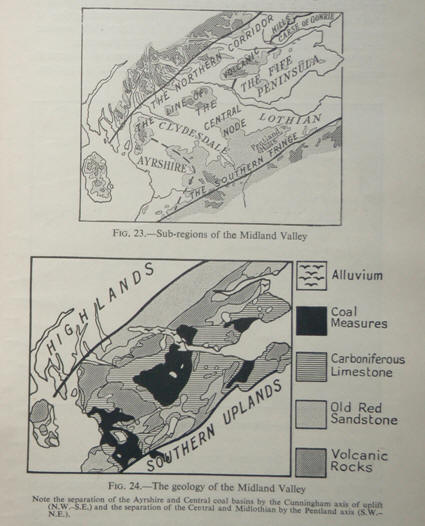
Old Red Sandstone, and was later occupied by a
shallow arm of the Carbonifeb01s sea, so shallow that at an early stage
it was suitable for the growth of the swamp forests which have left
their traces at the present day in seams of coal. At the same period
volcanic activity was rife, and as a general result at the present day
neither the relief nor the geology of the Midland Valley of Scotland can
be described as simple. It is only in the broadest possible sense a
valley. It is possible to distinguish a northern fringing corridor or
broad valley, then a line of volcanic hills, then the central lowlands
wherein lie the great Lanarkshire or Central Coalfields and the
Midlthiaifeshire Coalfield, then a line of hills along the south and an
ill-defined valley separating them in turn from the Southern Uplands.
These sub-divisions of the valley and their correlation with the geology
may be seen in Figs. 23 and 24.
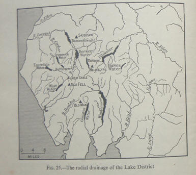
(4)
The Lake District or Cumbria._The
folding of the mountains which now make up the Lake District probably
commenced even as early as Ordovician times, but the main earth
movements responsible for the formation of the group were, like those of
the Southern Uplands and of the Highlands, the great CaledOflian
movements. Consequently the geological structures in the main part of
the Lake District have a trend from south-west to north-east and there
is no doubt that originally the Isle of Man and the Lake District were
joined and formed a single great chain of mountains. But the mountains
suffered great denudation, and at a later stage the waters of the
Carboniferous sea washed round them and may even have submerged the
whole, so that Carboniferous Limestone was deposited on the flanks of
the old central core. At a later stage—probably during the Alpine earth
movement local uplift occurred in the heart of the Lake District. The
uplift may have been due to a great mass of molten material in the lower layers of the earth’s crust
attempting, without success, to force its way to the earth’s surface.
Whatever its cause, the uplift has undoubtedly resulted in the two great
characteristic features of the area of the present day. These two
features are the occurrence of the main mass of ancient rocks in the
heart of the area, surround by younger rocks which in general dip away
from the centre core. In the second place the uplift seems to have been
responsible for the initiation of one of the most remarkable examples of
radial drainage which is known. The well-known lakes of the Lake
District radiate like the spokes of a wheel from a central hub, and it
is because this uplift took place at a comparatively late Stage that the
forces of denudattohi arc still active.
The District has some of the finest rock scenery
and, us the Lake I Isles. Gec. atiVClY low altitude, rugged mountains in
the Britisl despite their graphicaflY there is a rcma1kalcontrast
between the area of ancient rocks in the heart of the Lake District and
the surrounding ring of oungr strata Only on the south-east do the
Shapflnines. the Lake District proper with the hill masses of the Pc
Fells connect (5) WaleS or the Welsh ft if.—For the purposes of a
general account the whole of the Welsh massif may be considered
together.
For this purpose the massif may be described as embracing
all the hill masses which lie to the west of the English Midlands, excluding
only the southern part of the county of Glamorgan, which actually ought to be
considered as part of the English plain or scarplands. The eastern margins of
the area So defined can be quite clearly traced from any physical map. I the
north the Welsh hills abut quite abruptly on the Cheshire and north ShroP shire
plain; along the margin lies the North Wales Coalfield. The hills of central and
southern Shropshire belong structurally to the Welsh massif, and from central
Shropshire southwards to the mouth of the Severn the eastern limit is defined by
the line of hills running southwards from the Wrekin in Shropshire to the
Abberley Hills and the Malvern Hills. The oldest part of the Welsh massif is in
the north-west, where the ancient crystalline rocks of the isle of Anglesey
underwent folding in Pre-Cambrian times. The folding was continued during the
Caledonian earth movements and postC arboniferous foldings followed along the
same lines, so that one finds narrow bands of Carboniferous Limestone pinched in
amongst the ancient rocks. The whole of Anglesey, as the result of later
denudation, has been worn down to a low plateau, almost to a sea- level plain,
and its complicated geological history is scarcely sugg ested by the somewhat
uninteresting surface features of the island.
The mainland of north Wales is
still, on the other hand, a land of rugged mountains. On the whole the grain of
the country is from south-west to north-east, indicating that the mountains owe
their origin in the main to the Caledonian earth movements. The rocks involved
in the folding are, for the most part, Cambrian, Ordovician and Silurian, but
the mountains owe their rugged character of to-day to the large masses of
contemporaneous lava which were extruded as well as to other igneous masses
which were intruded into the rocks before and during the folding. The igneous
rocks have proved themselves more resistant to weathering, and most of the
higher points, such for example as Snowdon and Cader Idris, mark the outcrop of
one or more masses of igneous rock. As one passes from north into central Wales,
the igneous masses become less numerous, and this is one reason for the less
rugged relief of central Wales. The age of the folding of the rocks, too,
becomes successively younger as one goes towards the south. Whilst north and
central Wales, which at that time were probably continuous with south-eastern
Ireland, formed the land mass which we have already called St. George’s Land in
Carboniferous times, south Wales was occupied first by the Carboniferous
Limestone sea, then by the fringing swampy lands on which grew the Coal Measure
forests. Coal Measures were laid down over a huge area in South Wales, and at
the end of the Carboniferous period were folded by the Carbo-Permian or
Armorican earth movements. These earth movements resulted there in folds with an
east—west trend, thus causing the great coal basin of the South Wales Coalfield.
It would seem that the Armorican earth movements were unable to fold the already
highly complicated and hardened masses of North Wales, and that the
earth-building waves broke against this resistant mass both along its southern
and eastern sides. Thus there are east—west folds in the south, but north—south
folds in the east. Some of the latter are remarkably sharp, and one forms that
curious line of hills, the Malvern Hills. The Malvern Hills folds are
noted, coincide with low uplands, the Keuper
Mans with low ground, gently undulating but otherwise rather
featureless. It must be remembered that over very many areas the
underlying solid rocks are masked by the glacial drifts.
To the south-east the Keuper Marls are succeeded by the Rhetic and
Liassic rocks. Unless the Rhetic or lower Lias contain hard or resistant
beds sufficiently important to give rise to a scarp there is little to
mark the junction. Thus the Vale of Evesham is partly on Keuper, partly
on Lias; so also is the Vale of Berkeley. The Plain of
Lancastria.—The plain of Lancastria
forms a cont inuation of the Midland Plain through the Midland Gap or
Midl and Gate. It occupies the northern half of Shropshire, nearly the
whole of Cheshire and that part of Lancashire which lies between the
Pennines and the Irish Sea. There are two broad tongues of moorland,
called respectively Bowland “Forest” and Rossendale “Forest,” which
extend westwards from the Pennines into Lancas hire and which coincide
with outcrops of Carboniferous Rocks (Millstone Grit and Lower Coal
Measures). Elsewhere Lancashire is an undulating lowland: again, where
Bunter Sandstones outcrop there may be low hills, where the Keuper Mans
are at the surface true lowland prevails. The actual character of the
surface, however, depends largely on the thickness and type of the
mantle of glacial deposits. Physically the plain of Lancastria lies
between the Welsh massif and the Pennines: on the west the undulating
country of the North Wales Coalfield forms a transitional belt; in the
east the coal measure country of the North Staffordshire Coalfield forms
another transitional belt.
The North-Eastern Lowlands of Nottinghamshire,
Yorkshire, Durham, and Northumberland. On the eastern side of the Pennines, and
thus corresponding to the Plain of Lancastria on the west, is a broad belt,
mainly of lowland. The Carboniferous Limestone and Millstone Grit formations
which make up the bulk of the Pennines dip eastwards, and are succeeded in turn
by the Lower Coal Measures, the Middle and Upper Coal Measures, the IMagnesian
Limestone and higher Permian beds, the Bunter Sandstone and the Keuper Mans. In
general terms each succeeding formation gives rise to its own characteristic
type of country. Thus there is a success ion of physiographic zones roughly
parallel to the Pennines. The Lower Coal Measures give rise to rather barren
land with patches of moorland separated from one another by river valleys. The
more fertile country of the Middle and Upper Coal Measures has a gentler relief,
but resistant beds may form westward facing scarps (see Fig. 218). Tongues of
lowland extend into the heart of the Pennines along the famous “Yorkshire Dales
“—particularly those formed, from north to south, by the Swale, Ure, Nidd,
Wharfe, Aire, Calder, and Don. The Magnesian Limestone usually forms a distinct
west- ward facing scarP, often with attractive cliff scenery, especially at
those places where the scarp is cut through by rivers. The Bunter Sandstone, as
in the Midlands, coincides with sandy, rather elevated tracts, infertile and
hence often well wooded as in the well-known Sherwood Forest. Occasionally
marked bluffs are found, such as that on which Nottingham Castle is situated.
The final belt is that of the Keuper Marls and is the lowland belt which
stretches from the mouth of the Tees to the Trent Vale of Nottinghamshire, but
the Keuper Mans are masked by superficial deposits over large areas, over that
huge tract known as the Vale of York, and the interesting area of the Isle of Axholme.
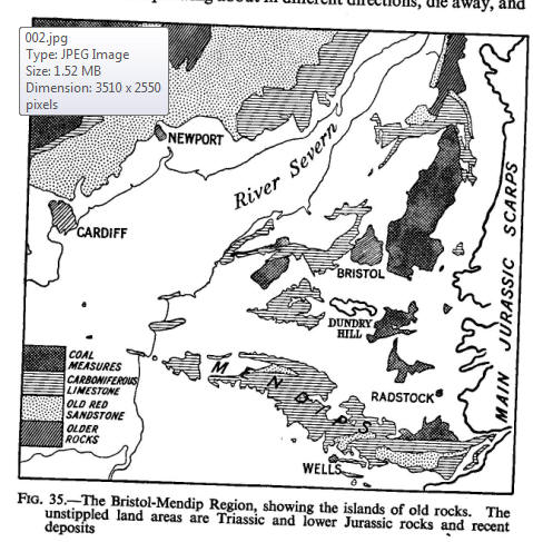
The
Bristol-Mendip Region.—To the south-west the Midland Plain narrows and
passes first into the Vale of Gloucester and then into the Vale of
Berkeley between the Forest of Dean or the Severn on the west, and the fine
scarp of the Cotswolds on the east. But farther southwards, in what may be
called the Bristol-Mendip Region, the plain disappears. Its place is taken by
country of varied rel ief lying between the Severn and the westernmost of the
Jurassic scarps. This region repeats, on a smaller scale, the features of parts
of the Midlands. It really consists of “islands” of old rocks wrapped round by
the softer Triassic and Liassic deposits. But there are several points of
difference: the islands are relatively larger and more numerous, the amount of
low ground correspondingly small. The islands, too, are of rocks of varied age;
there are the large Carboniferous Limestone masses of the Mendip Hills, and the
imi portant coal basins, as well as quite tiny patches of Silurian, Old Red
Sandstone and Carboniferous Limestone. The “islands” are
)remnants of Armorican folds, and it is in this region that the north—
• south Malvernian folds cross the more normal east—west folds. iThus some of
the old blocks are elongated in a north—south direct 1on, such as the Tortworth
Ridge north of Bristol and the Carboni‘ .. Limestone edges of the Kingswood coal
basin. In
the Mendips a succession of east—west folds en echelon has resulted in a d upland trending from
west—north—west to east—south—east.
‘- Plain of Somerset.—In some ways this plain resembles that Midlands from which
it is separated by the
Bristol-Mendip The Vale of
Taunton Deane is thus a Keuper Marl lowland,
the great feature of Somerset is the very extensive plain, almost sea-level and
liable to extensive floods, which lies between the lantock Hills and the
Mendip Hills, and which is interrupted only the narrow Liassic ridge of the
Polden Hills.
L Jurassic Scarplands.—The Jurassic rocks of Britain crop over a belt of varying
width extending from the
Dorset coast the north Yorkshire coast. Over large areas the beds dip to
South-east or east, and so give rise to a succession of hills or es where the
harder or more resistant beds crop out, and valleys