|
|
Environmental Consultants |
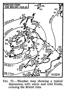
The passage of such a small depression is often,
one might say usually, followed by the passage of a ridge of high pressure,
ushered in by the continuation of the cold northerly winds and a steadily rising
barometer. Fine sunny weather may result in the summer, but as the winds
decrease and calm conditions prevail the passage of such a ridge of high
pressure is often marred in winter by the occurrence of fogs.
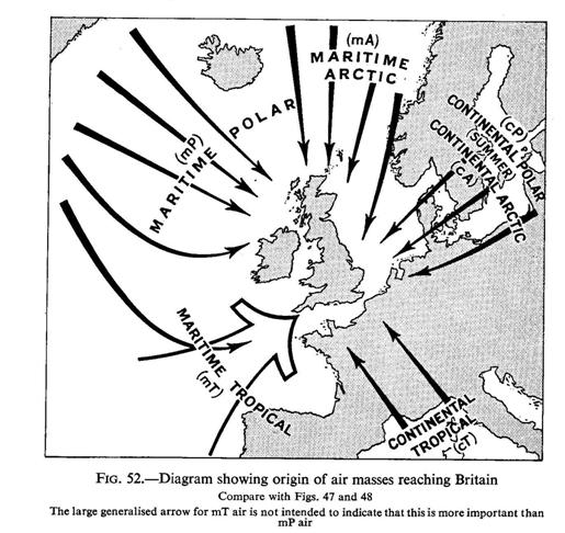
It is now possible to re-state what has been
said in the last few pages in modern terms by stating that the British Isles are
affected by six principal types of air or air masses. Most of the air reaching
Britain can be traced to one of three main source-regions—regions where the air
has had sufficient time, such as a number of days, to acquire a degree of
homogeneity of temperature and humidity throughout its mass. These three source
regions are the Arctic, eastern Europe or Eurasia and the Atlantic high pressure
area of the Azores—precisely the areas already clearly indicated ot
| Fig. 47. The Arctic yields maritime Polar air (mP) which may be intensified as a bitterly cold northerly air stream in winter when it is designated maritime Arctic (mA). Northern Russia and Siberia give us our most severe winter weather through the mass of contin ental Arctic air (cA) contrasted with the rather rare continental polar (cP) and continental Arctic (CA) of Summer where air masses from the same quarter have been warmed in their passage eastwards. The rarity of such air masses reaching Britain is clear from Figs. 49 and 50 which show th& normal movement away from Britain. The Atlantic area over the Azores yields maritime Tropical (mT) air; much rarer (alm ost unknown in winter) is continental Tropical(CT) from North Africa or the summer Mediterranean. |
|
The Equinoxes
In the analysis of the general conditions in Europe we referred to the formation of a great high pressure centre over eastern Europe in winter and the formation of a low pressure centre over the same area in summer. Naturally there must be two seasons of the year when the change from one to the other takes place, and it is very largely the resulting disturbance of atmospheric conditions which is responsible for the well known equinoctial gales experienced in this country. Whilst in the early part of the year high winds are associated with the month of March and the fame of March winds is perpetuated in many a nursery rhyme and popular ballad, the change indicated by these winds does not always take place at exactly the same time. In some years March may “come in like the lion and go out like the lamb,” in others it may come in like the lamb when the winter conditions still prevail, but go out like the lion. The corresponding high winds associated with the disturbances at the autumnal equinox are the equinoctial gales of September and October. After the equinoctial gales of March come the still
 |
 |
Temperatures
So far we have been dealing with the weather
conditions of the British Isles, and owing to the irregular succession of
weather it is sometimes said that the British Isles have no climate, since
climate is described as the average state of the weather. This may at least
serve as a useful reminder that we should use the averages mentioned in the
paragraph below with care owing to the variability from year to year, and even
during one year. Taking, first, temp erature conditions in the winter, it may be
said that in general conditions in the British Isles reflect in detail those
prevailing in Europe as a whole. In winter the west is warmer than the east and
the isotherm of 40 degrees in January roughly divides the islands into two and
its curve should be carefully noted. As one would expect at this season, the
extreme south-west of Britain and
south-western Ireland are, taking the average
conditions in January, the warmest parts of the islands. The Scilly Isles have
an average temperature in January of no less than
45
degrees, whilst snow and frost are both rare.. The
important effects which this has on the products which are possible in these
areas, and on the use of warmer parts of Britain in winter as winter resorts,
may be mentioned. Taking the evidence afforded by the isotherms alone the
coldest parts in the British Isles in Winter are certain tracts down the east
coast, and it would seem that the east coast of Scotland in the neighbourhoo1 of
Aberdeen is not as cold as some parts of the coast of East Anglia farther south,
but the ordinary dry- bulb thermometer is scarcely an adequate measure of
temperature in so far as it affects human beings and there is perhaps a rawer
quality in the air in northern tracts. In summer, by way of contrast, the south
of the British Isles is warmer than the north. The isotherm of 60 degrees in
July runs roughly from east to west. The south-east quarter is the warmest of
all in July in the neighbour hood of London, but the average along the south
coast is high. The coolest parts of the islands at this season of the year are
the extreme north of Scotland, the Orkneys and the Shetlands Though geographers
have long been accustomed perhaps too slavishly—to take January and July as the
typical Winter and summer months, they are not in the British Isles the Coldest
and warmest months respectively. It frequently happens in oceanic or insular
climates that there is a considerable lag between the period when the sun’s rays
strike least obliquely or most obliquely on the surface of the ground and the
time when the highest and owest average temperatures are reached, so that for
many part
 |
 |
So far we have been considering temperature as it affects lowlands, and the isotherms which have been discussed are sea level isotherms. If one considers the actual surface temperatures as recorded the theoretical difference between actual temperature and temperature reduced to sea level is 10 F. for every 300 feet. Since the greater part of Lowland Britain is less than 600 feet above sea level the theoretical difference does not exceed 2° F. Elevation begins to exert an important effect on the higher ground of Highland Britain and on the top of the highest point in the British Isles, Ben Nevis, at 4,400 feet, the temperature if reduced to sea level equivalent would be nearly 150 F. higher.
The effect of elevation justifies us in regarding the
Highlands of Scotland in January as the coldest part of the country. The factor
of elevation is readily apparent when snowfall is considered (see Fig. 62).
Whilst in the south-west of the country, in
Devon and
Cornwall, snow does not
normally fall on more than five days in each year, and is not found to be lying
for more than five days, such lofty tracts as Dartmoor are frequently seen to
have a powdering of snow. Indeed, on the higher parts of Dartmoor snow normally
lies for more than twenty days in every year.
The effect of elevation on temperature is however far from simple. Cold air
behaves much like cold water. It flows downhill and will collect in a valley or
basin where there is no outlet and gives rise to a “frost pocket” or “frost
hollows.” Some extremely low temp eratures have been recorded in such obstructed
valley situations amongst the Chiltern Hills. On the other hand, where cold air
can drain freely as it does down river valleys and out over the sea, such frost
pockets are absent.
Studies which have been undertaken in connection with the growing of fruit and
the siting of fruit orchards have shown how very important it is to secure free
drainage of air. Even a high hedge can hold up air movement and increase the
hazards of frost. In addition aspect plays a much greater part in the
determination of local climates than has been suspected in the past. If one
attempts to determine the upper limit of cultivation in such areas as the
Pennines, one finds that cultivation is almost invariably to a higher level on
the northern sides of valleys, that is to say on those slopes facing southwards
towards the sun, than it is on the southern sides of the valleys. Dr. Alice
Garnett1 has carried out elaborate studies showing how important this fact is in
the Pennine valleys of West Yorkshire. Hills running from east to west afford a
remarkable protection from cold northerly or north-easterly winds. The
attraction of
 |