|
|
Environmental Consultants |
THE variability of British weather has long
been a byword and, as every holiday-maker knows, the most reliable of British
weather experts are apt to be misled, at least at times, in their attempts to
forecast the coming weather. Until recently atmospheric conditions at or near
the surface of the earth were those which most concerned its hawian inhabitants.
With the coming of the airplane the conditions in the higher layers of the
earth’s atmosphere suddenly became of considerable importance. It was during the
First World War that innumerable investigations had almost perforce to be
carried out in the higher layers of the atmosphere in studying the behaviour of
air currents and the occurrence of “air pockets.” It was largely as a result of
these investigations, previously of interest mainly to the scientific
meteorologist, that ideas concerning the causation of weather conditions were
fundamentally changed. The old dogmatic statements of the textbooks can no
longer be received, but at the same time it is not yet possible to state fully
in simple terms, or with general assurance, the results of modern studies.
The old concept of the planetary wind systems
placed the British Isles in the belt of the “South-West Anti-Trades,” later
described more accurately as the Westerlies or Variables. The development of the
Polar Front hypothesis associated especially with the name of Bjerknes and his
colleagues of the Norwegian school of meteorologists led to the current concepts
of air-masses of differing origin and the phenomena associated with the fronts
along which these air-masses meet. The development of radio has led to entirely
new knowledge of the character of the upper atmosphere. Nevertheless, we can
still state simply that a number of factors have a determining influence on the
character of British weather and climate. The factors may be grouped as follows:
in ameliorating winter conditions. To the north and north-east of the British
Isles no land barrier exists to prevent the flow of water. It therefore makes
its influence felt right along the coast of Norway to well within the Arctic
Circle, with the result that even the Murmansk coast of northern Russia remains
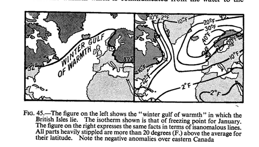
free from ice throughout the winter. The British Isles thus lie within the well
known winter gulf of warmth and possess a milder climate than any other region
in corresponding latitudes. They afford a remarkable contrast in this respect to
lands such as Northern Japan or Labrador, which are situated on the eastern side
of continental masses, and which are under the influence of cold ocean currents.
It must be remembered that the direct effect of the warm waters themselves is
much less important actually than the warmth which is communicated from the
water to the prevalent
south-westerly winds. The existence of the Continental Shelf round Britain
enhances the influence of the waters in that they are spread out over a wide
area and thus exert a maximum influence in warming the overlying air.
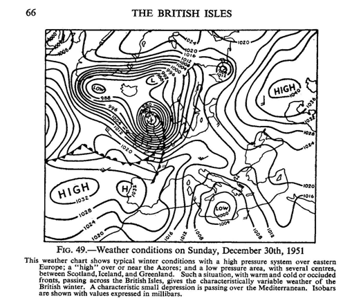
| (b) Except perhaps for certain periods in winter the British Isles lie wholly within what has long been called the westerly wind belt. There is not, of course, at any season of the year a constant westerly or south-westerly wind, although the southwest erly is the dominant wind in these islands. What is perhaps more important is the fact that the greater part of our weather comes from the south-west, that is from across the Atlantic, and that these islands are greatly affected by what are now described as maritime tropical (mT) air masses. The sequence of British weather depends very largely on a series of whirls and eddies in the atmosphere (to which we give the name depressions, or “lows”) and intervening wedges of high pressure which move across these islands in a direction which is generally from the south-west. By comparing the daily weather maps published by the Meteorological Office for successive days, |
|
it is often
possible to trace the movements of the individual depressions across the
Atlantic Ocean. On the other hand, any long range forecasting based on the
weather experienced on the other side of the Atlantic is obviously liable to go
wrong, since the dep ressions may become filled up and disappear in the course
of their passage across the Atlantic or their path may lie to the north or to
the south of the British Isles. The sequence of weather during the passage of R
depression is well known, but changes in the rate of progression and in the
intensity of depressions present considerable difficulties to the forecaster.
Further reference will be made later to the character and causation of these
depressions.
 |
 |
(c)
The configuration of the British Isles, particularly
the existence of numerous inlets, so that no part of the country is far from the
sea, makes the penetration inland of oceanic influences more than would
otherwise be the case. The existence of the principal hill masses of Britain on
the western side of the islands, combined with the fact that the main
rain-bearing winds blow from the south-west, results in a very marked difference
in the amount of rainfall on the west and on the east. If it were not for this
surface relief the whole of the British Isles would experience a moist climate,
more like that of Ireland. It will now be clear that the passage of
depressions, or cyclones, over these islands has a dominating influence in
determining the character of our daily weather. Thus the causa1tion of
these whirls in the air is a matter of some importance. According to the Polar
Front hypothesis first developed by the Norwegian school a very important
difference is found between cold
Polar air and warm air moving from the
south
The position and the amount of the cold Polar air
varies with the seasons, and this mass of cold heavy air may be regarded as
having a front, or southern limit, known as the Polar Front, lying normally
somewhere to the north of the British Isles, not infrequently at least in the
neighbourhood of Iceland. It has been suggested in winter that the Polar Front
may be regarded
very roughly as following the 32° F. isotherm.
It is the friction between the current of tropical warm air and the cold, almost
stagnant Polar air that is believed to give rise to the succession of cyclones
which we associate with the Polar Front. The formation of cyclones on this
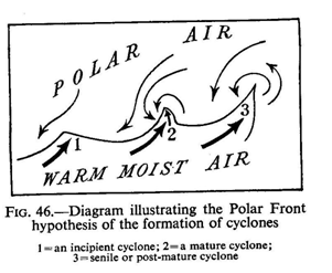
hypothesis is best understood by reference to the diagram. It will be seen that
a whirling motion of the air is set up in which the winds blow round a centre,
actually a low pressure centre, in a counter-clockwise direction. Where the warm
moisture-laden air meets the cold Polar Front condensation takes place,
especially when the warm air is forced over the cold air. The indraught of cold
air from the north which marks the passing of the cyclone is accompanied by a
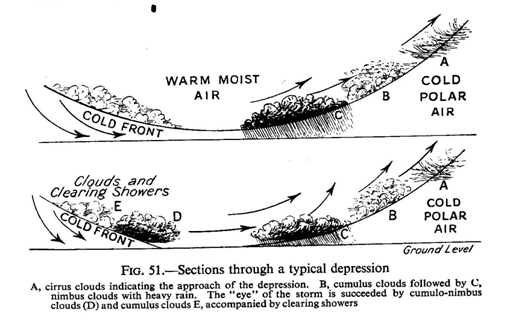
drop in temperature, but, after an initial cloudiness explained in Fig.
51,
by a clearing of the sky. If one accepts this explanat
ion of the formation of depressions, the fact that the Polar Front is
approximately over Iceland would result in a Continuous success ion of
depressions passing across Iceland in a north-easterly direct ion. If one takes
an average of such conditions one gets the conception of a semi-permanent low
pressure system situated app roximately off Iceland.
Weather and Climate of North-West Europe
Before considering the weather conditions in
the British Isles in particular, it will be necessary to look at the weather
conditions affecting the whole of Europe, and it is simplest to do this by
contrasting the winter and the summer conditions.
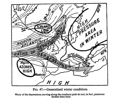
Winter conditions.—Jn
the winter months the Continent of Europe lies
in the belt of the westerly winds, warm moisture-laden winds from the Atlantic
Ocean. The extra-tropical belt of high pressure at this season lies well to the
south of the Continent—over the Sahara and its continuation into the Atlantic
Ocean to the south of the Azores. Thus there is a high pressure area over the
Azores and, as we have already seen, a semi-permanent low pressure system
roughly over Iceland. But the eastern part of the Continent is very near the
great land mass of central Asia, of which it is indeed• a continuation, and so
at this season gets extremely cold. One may picture a great mass of cold heavy
air over Asia and eastern Europe, giving rise to a permanent high pressure
system in the winter.
|
The warm moisture-laden air from the Atlantic
blows up against this, as against a wall, and either finds a way of
escape to the north-east along the coast of Norway, or a way of escape
to the south along the Mediterranean. At times this great high pressure
system of eastern Europe, with its cold outblowing winds, may exert its
influence even as far as the eastern shores of the British Isles and may
therefore give rise to cold and frosty, though often sunny, weather.
Indeed it may be said that the winter weather of the British Isles is
determined by the relative strength or importance of these three great
pressure systems—the semi-permanent low pressure system over Iceland,
the permanent high pressure system over eastern Europe, and the high
pressure system south of the Azores. Bearing these facts in mind it is
not difficult to understand why in the winter months it becomes steadily
colder as one travels eastwards across the British Isles and, indeed, as
one travels eastwards in Europe. In Europe we find that the isotherm of 320, or freezing point, divides the Continent roughly into two halves and, as we have already noted above, we may look upon this isotherm as marking approximately the position at this season of the Polar Front. Thus the cold mass air over Russia and eastern Europe may be regarded as lying within the Polar Front. At this season the moisture-laden winds from the west deposit their moisture on the western sides of the land masses; they are unable to penetrate very far towards the east and so there is comparatively little precipitation in the east. This is apparent even in the British Isles, where in the western half of the islands more than half of the total rainfall comes in the winter |
 |
 |
 |
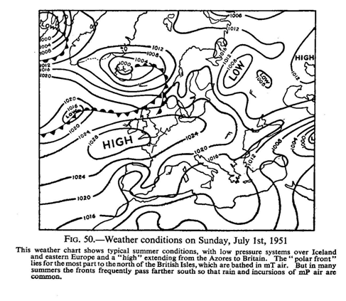 |
must lie across these islands in both seasons of
the year. Since this is the case it is desirable to examine in a little
more detail the succession of weather which results. One must remember
that a cyclone or depression in the Northern Hemisphere is marked by a
low pressure centre with upward currents of air. Winds tend to blow
round this centre, for reasons which have already been exp laifled in an
anti-clockwise direction, and at the same time towards the centre, where
they rise. When a depression, therefore, is approaching these islands
from the Atlantic the barometer will fall and winds will be southerly to
south-westerly, veering westerly later. Coming from the Atlantic, they
will be warm and moisture- laden, blowing northwards towards cooler
regions and also towards the central depression where they will rise, rain
begins to fall. Where the oncoming warm south-westerly winds meet the
colder air, the “warm front,” as it is called, is formed and along this
warm front, where the air is cooled by rising over the cold air, rain is
likely to occur, and prolonged steady rain may result. Subsequently
there is usually a break in the weather. After the centre of the
depression has passed across the islands, usually in a normally
easterly, or north-easterly, direction, the barometer will again rise
and the normal air currents will now be the colder winds from the north
or north-west. These winds are comparatively dry, but where they impinge
on the flanks of the south-westerly current intense rain with squalls
may result. This is shown in the diagram. Actually the diagram
illustrates a cyclone probably along the Polar Front itself, but the
passage of a smaller secondary depression across the islands would
produce comparable weather conditions. |